

Vieques is home to some of the best beaches in Puerto Rico, offering a perfect mix of crystal-clear water, white sand beaches, and secluded tropical escapes. Whether you are planning a Vieques vacation or searching for things to do in Vieques, the island’s coastline delivers unforgettable experiences. From the world-famous shores of Sun Bay Beach and Media Luna Beach to hidden gems like Playa Negra and La Chiva Beach (Blue Beach), visitors can enjoy snorkeling, swimming, sunbathing, and beach hopping all in one day. Many travelers researching Puerto Rico travel guides and Vieques travel tips discover that these beaches are uncrowded, naturally preserved, and easy to explore. With year-round warm weather and some of the most beautiful beaches in the Caribbean, Vieques is the ideal destination for those looking to relax, explore nature, and experience the island’s unique coastal beauty.
SOUTH SIDE BEACHES

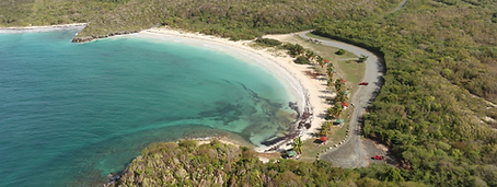
Media Luna Enter the gated entrance off 997 at Sunbay. Follow the dirt road at the end of Sunbay and travel 0.6 more miles to Media Luna. Great for small children, Media Luna is shallow. You can walk 30 ft out into the water and still be in waist deep water. Also, for a free “spa experience,” enjoy an exfoliation from the silky, fine sand.

Navio Follow directions to Media Luna but pass Media Luna and take a left at the sign and go another 0.3 miles. The road is extremely rough and 4wd is sometimesrequired but you can also park at Media Luna and walk to Navío. Go into the cave on the left side of the beach (if facing the water) for an excellent photo spot! There’s good surf so bring your boogie board!


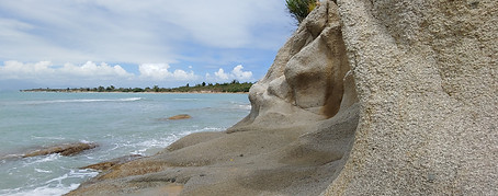
Playa Negra (Black Sand Beach) Leave Esperanza on 996 going west. Come to T (201) and take left. Drive 0.1 mile and there will be a guard rail and small pull off on your left. Drive 100 feet more to Gallery Oro and park in the lot across the street. Walk down the path to the dried stream bed and follow to the right. It is about a 20 minute walk to the beach. If it has rained, stream bed will actually be a small stream. Bring bug spray and water. The black sand gets very hot so protect
your feet!


VIEQUES NATIONAL WILDLIFE REFUGE
Caracas From 997, turn into the Vieques National Wildlife Refuge at Km Marker 3.2. Go 2.6 miles to a sign for Caracas. Turn right and go .7 more miles. Little shade except for picnic gazebos in the grass area. Watch out for the sandburs! Be very careful where you step when you are in the grassy area and kids should wear their shoes down to the sand (or water’s edge). Note: Only park in the parking lot, and not in the entire cul-de-sac at the very end, to avoid fines. It is only for emergency vehicle turn around.

Pata Prieta From 997, turn into the Wildlife Refuge at Km Marker 3.2 and go aprox 2 miles. Pass turn to Caracas and continue straight on dirt road for aprox 1 mile and turn right at Pata Prieta sign. After 0.2 miles, follow the road to the right to a small parking area with sign. Walk down the gravel path to the left of the sign to the beach. Bring a beach umbrella as there is little shade!

La Chiva From 997, turn into the Wildlife Refuge at Km Marker 3.2 and go aprox. 2 miles to the end of the paved road. Pass the sign for Caracas and continue straight on the dirt road. La Chiva has numbered spots #1-20. At marker #11 the road splits so stay right if you want to explore La Chiva spots #16-21.


Playa Novillo Playa Novillo (also referred to as Navillo) is a secluded, picturesque white sand beach on the southern coast of Vieques, accessible via a dedicated hiking trail in the Vieques National Wildlife Refuge. It is known for its quiet, untouched nature, often described as a "picture-perfect", secluded spot.

ON THE WEST SIDE
Playa Grande Leave Esperanza on 996 going west and come to a T (rt. 201). Take a left. Go 1 mile to where the road dead ends and take a left. Follow road to the bottom of the hill, where you will be entering the southwest area of the Wildlife Refuge. Take a right onto dirt road to find a beach spot. Great beach for walking. Playa Grande is a turtle nesting beach so be sure to keep dogs on a leash and watch out for roped off nests. If you follow the dirt road west, you will run into the rugged Punta Vaca beach area. Good for hiking and nature exploration, but not safe for swimming.

Punta Arenas Follow directions to Rompeolas (north shore), but pass the pier turn and drive about 2 miles to the northwest Refuge entrance. Continue 1 mile to a T-intersection; both left and right lead to beach spots, but the best snorkeling is to the left. Bring water and bug spray, as no-see-ums appear in the late afternoon. The area gets busy with anchored boats on holidays. To get the most out of this snorkel, go with a guide—you’ll miss a lot if you don’t know where to look.
NORTH SIDE BEACHES
Playa los Muertos (Sea Glass Beach) Drive into Isabel II on 200 and make a left onto main street (Calle Muñoz Rivera). Almost at the end of the street you will see an intersection with a church on your right. Make a left here and at the next intersection make a right. Park on the street (not in the yellow!) and walk to the left of the gazebo down a path to the beach.

La Chata Drive by the ferry on your left and go up the steep hill to the right of El Yaté Bar. Go by the lighthouse on your left and take the next right down a steep little hill. Curve to your left and follow along this shoreline road. Pass La Lanchita on left and drive aproximately 0.35 miles to a left turn onto a small dirt drive with two palms and large rocks at the end. La Chata! Keep your eyes open for sea glass. Don’t be surprised if you are swimming with horses! Many people come here to exercise them.


Rompeolas From the Ceiba tree, continue along Route 200 and turn right at the empty concrete structure or lot; the road leads to the pier. The pier is about a mile long and popular with joggers and walkers. Excellent snorkeling can be found on the left (west) side but go with a guide for the best experience. Watch out for low-hanging concrete under the pier, and be aware that the cargo barge docks twice daily, bringing traffic in the early morning and late evening.

